
We’re back to the time of year when the predominance of Starlink satellites can be briefly illuminated low over the northern horizon as the sun approaches the Summer Solstice here in the mid-latitudes of the northern hemisphere. This predictable phenomenon is currently little known, and recognized only by the few who have directly observed it (and chosen not to attribute the ‘bright lights in the sky’ to UAP phenomena). This phenomenon of concentrated flaring has been occasionally reported by airline pilots who often have clear views at night from high altitudes in the polar directions (northwest to northeast in the northern hemisphere, etc.), which makes the satellites easier to observe; see the HeavensAbove.com diagrams below for a graphical depiction of the illuminated satellites.
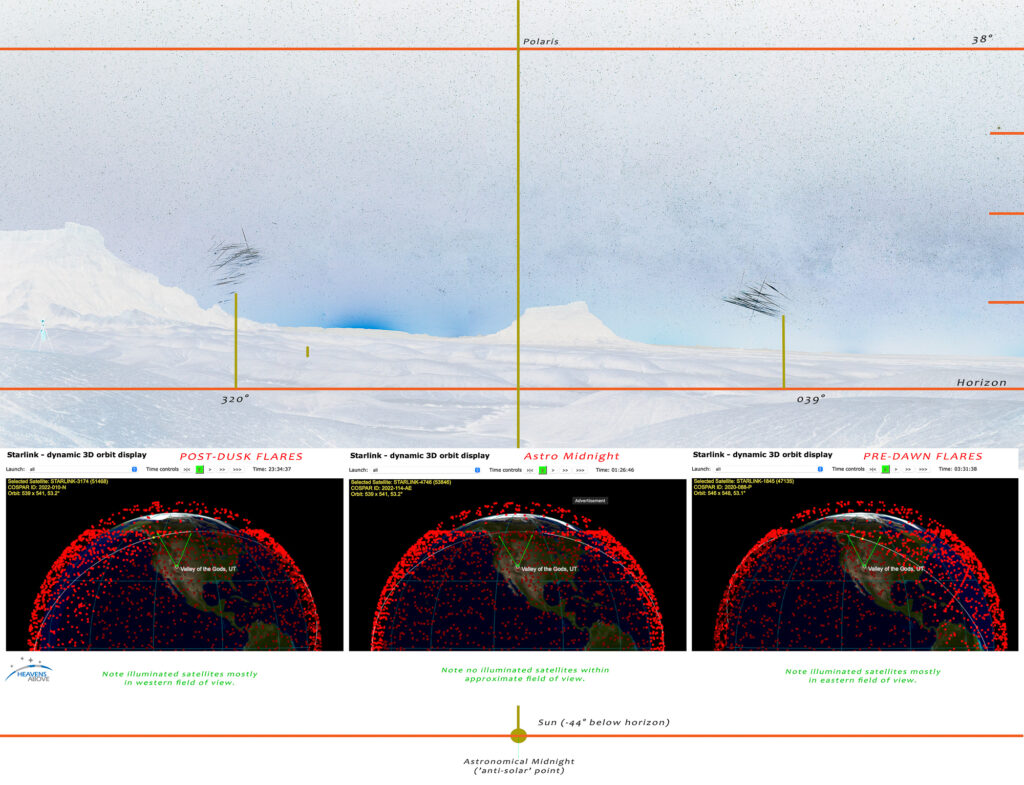
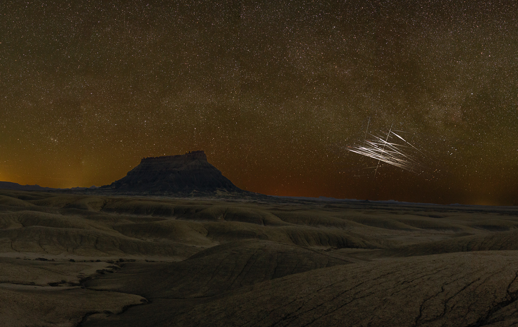
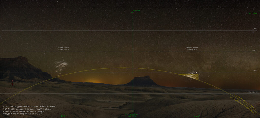
I first directly observed this last April while shooting night panoramas in San Juan County, UT, and described the phenomenon as ‘satellites flaring at their most-northerly orbits’, but am now adopting ‘satellite swarm’ as it seems more apt. If you know when and where to look this time of year this flaring is quite a sight, as the brighter flares that occur at ~8° above the horizon can reach magnitudes approaching -3! I routinely witness as many as 5 satellites within the limited field of view of typical binoculars, and the flaring generally occurs over about 30 seconds, with the brightest reflections occurring for as little as 5-8 seconds. There are two flare phases visually apparent occurring just after equinox: 1) a ‘dusk flare’ that occurs in the northwest part of the sky (~10° in elevation) ~90 minutes prior to ‘astronomical midnight’ (e.g. when the sun is at its lowest point below the horizon) , and 2) a ‘dawn flare’ that occurs approximately 90 minutes after astronomical midnight and is observed in the northeast.
In considering this and researching the geometry of this flaring over the last year, it’s become clear to me that there seems to be no standard definition of the term ‘satellite flare’. While it is true that any satellite which is visible in the sky is in an illuminated phase (e.g. a ‘transit’), during post-dusk and pre-dawn hours satellites can remain fairly evenly illuminated for 90-120° across the sky, over the course of several minutes. It thus seems more useful to define a satellite ‘flare’ as a significant increase in brightness occurring over a relatively limited timeframe, perhaps 40 seconds or less (an arbitrary definition and duration, admittedly). I suppose it could also be defined by the relative change in brightness over time, (for example, an increase of brightness of 3x, or whatever). Alas, I digress.
As an aside, in the past the satellite flaring phenomenon became most-widely known as a result of the prior generation of Iridium satellites predictably ‘flaring’ over a 4-6 second time period, the bright flares of which could easily be seen even during the brighter periods of twilight. These satellites no longer flare in this manner as they became non-operational (now replaced by a new Iridium constellation), and have since been wholly de-orbited.
Flares of this type are essentially direct specular reflections of the sun (which lies beneath the horizon) off of either large solar panel arrays or the underside of spacecraft that are oriented such that the reflection can be seen by an observer on Earth. Typically, the shorter the duration, the brighter the flare, although there are many aspects that work into the characteristics of a given flare, not the least of which is the generally unknown orientation of the satellite’s reflective surface. This is especially true of Starlink satellites, as SpaceX is constantly changing the orientation of the satellite/solar arrays as they progress through their orbits, for the purpose of brightness mitigation in relation to astronomy.
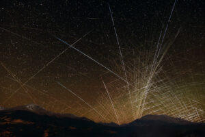
In regard to the images presented here, they are essentially an analog of typical meteor shower composites which show only the meteors on a base image of the sky (as opposed to being presented in a star trail image, which would make the flares harder to pick out amongst the abundant star trails). For these images I have chosen to keep each distinct flare in the part of the sky (relative to the horizon) in which they occurred, as opposed to laboriously re-orienting each flare to the stars in the background the way one would for a meteor shower composite. [As an aside, I have produced flare composites using both these methods, and they look substantively similar due to the limited timeframe over which the maximum flaring occurs, i.e. the stars don’t move ‘much’ over the course of 30 minutes.]
One last interesting note is on the geographic location of these flaring satellites during these low-altitude max-flaring events. The satellites in the panorama image above predominantly belong to Starlink’s 53° inclination orbital ‘shell’ (all launched from Florida), and thus they never get to a latitude higher than 53°. As the Earth rotates on its tilted axis, satellites repeatedly transit the highest latitude of their orbits every 90 minutes. What the images show in this ‘satellite swarm’ is the confluence of multiple orbital planes intersecting one part of the sky at this highest latitude of 53°, as viewed obliquely, looking north. The satellites are in the vicinity of Edmonton Alberta, approximately 1100 miles away, and are reflecting sunlight as they rotate into (and out of) the Earth’s shadow.
If you have questions please leave a note in the comments below, and I’ll try to respond in a timely manner! I’ll soon be creating a more detailed webpage documenting the source of this flaring phenomenon, once I gather a bit more data as we near Summer Solstice.

Sobo
13 Aug 2024Hello,
Do you have a higher quality image of the first picture of this article (https://catchingtime.com/wp-content/uploads/2024/04/R5_018281760_ISOLATED-PS-export-2.jpg)
It’s for personal use (wallpaper)
warnerjh
13 Aug 2024I do, what are the dimensions of your monitor?
Pingback: 5/6/24: "Earth Shadow" - CatchingTime
Bruno
21 Nov 2024Hello! I am grateful to have found this text so informative. I also recorded these stralink flares close to the horizon, in my case at 23º south latitude. Until I recorded it, I had never seen satellite flares so low at a time so far from sunrise. Thank you for the valuable information!
warnerjh
30 Nov 2024Glad I could help, Bruno. Lots of wild stuff to see in the night sky, you just never know what you might see!
Pingback: - CatchingTime