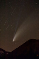
Having first captured intense flaring from certain orbital inclinations of the Starlink satellite constellation back in April 2023, I have since spent considerable effort to gather additional data in the form of imagery of these satellites. The extremely bright flaring that I randomly witnessed 14 months ago was like nothing I’d ever seen, kind of like a slow-speed meteor shower, but occurring in only one isolated part of the sky. It was wondrous to observe. Although I didn’t at the time know exactly what I was looking at, I knew from my understanding of the night sky what it had to be, that is, multiple planes of Starlink satellites converging on one geometrically apparent ‘point’, as reflected by the sun, which was directly beneath, below the horizon.
A few hours with the images and a couple of online astronomy references showed that these flares must be occurring predominantly in the 53° inclination orbital shell of SpaceX’s Starlink satellite constellation, the predominance of SpaceX satellites that have been launched to date. This specific ‘orbital shell’ provides an opportunity to illustrate the geometry of the mesh of satellites always overhead, and by late 2023 having captured the flaring phenomenon on a half-dozen occasions, I was beginning to understand both the spatial and temporal variability of the flares. It became clear to me that I could–at the right time of year–create an image of the shadow of the earth, as reflected by orbiting satellites overhead.
Wild.
IMAGE: “Earth Shadow”
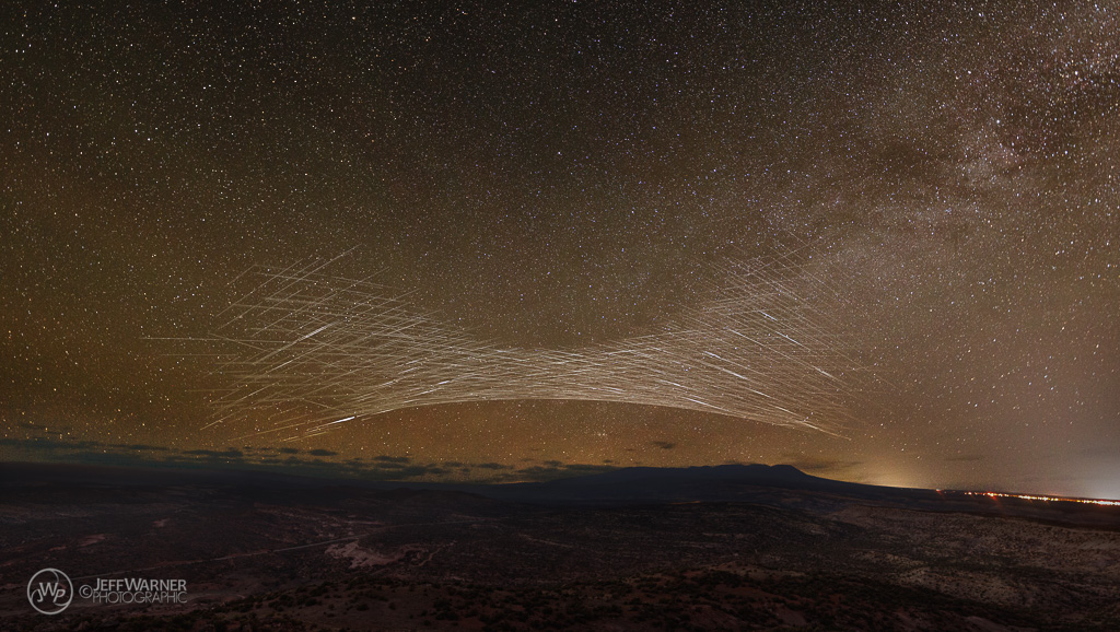
Five years ago this image could not have been captured, as the Starlink satellite constellation literally did not exist.
This image is the culmination of knowledge gained during dozens of hours shooting at night, and probably at least as much time processing the imagery. Since last April I’ve spent countless hours investigating this phenomenon, and initially I found that there was virtually no information out there; the phenomenon had gone largely unnoticed or un-observed, except for a few high-altitude airline pilots who happened to be looking out the cockpit window at the right time of year, from the right place, at the right time. One such observation back in August 2022 ended up being the first to be formally investigated by researchers, (Buettner, Griffiths, Snell & Stilley, 2024 and Mallama & Cole, May 2024), who in late 2023 concluded that the recently-launched Starlink satellites were the cause of the ‘lights in the sky’ that were reported as a UAP (unidentified aerial phenomenon). In August 2023, amateur photographers began training their cameras to the north to capture the Perseid meteor shower, at which time many captured the flares in wide-angle timelapses; some subsequently looked to the internet to discover the origin by posting questions to such places as Reddit’s r/UFOs subreddit. Over the last year I’ve spent considerable effort trying to educate the masses on these predictable events; of course, in a place like r/UFOs, they come to see UFOs, and that’s what most of them continue to ‘see’. That said, word is finally getting out, and now many ‘reports’ are no longer attributed to UFOs or relatively vanilla ‘Starlink trains’, but to the actual satellite flares that they are. I digress.
Photographic information:
The image above is a composite spanning 4 hours, two hours either side of astronomical midnight. Photographic capture data are as follows:
- Canon Eos R5: Sky 25 seconds, f/2.0, ISO 1600, Foreground 30 seconds, f/2.2, ISO 2000 (late blue hour)
- Sigma 14mm f/1.8 Art lens
- 540 images total spanning 4 hours, significant flares isolated from ~65% of the total images
- Base sky image captured at astronomical midnight, the sun’s lowest declination beneath the horizon for that day (the midpoint of the time interval)
Think of the result as similar to all the meteor shower composite images we’ve likely seen, only with satellite tracks instead of meteors.
Satellite tracks were isolated manually in Photoshop, ignoring the tracks from other orbital inclinations in order to be able to convey the geometry of the particular orbital shell shown, in this case both 53.05 and 53.2°, which is comprised of ~3368 operational satellites, currently more than half of all Starlink satellites in the sky. This is what allows such an image to be made, as the 28 orbital planes periodically converge at 53° North latitude (in the northern hemisphere) as the earth rotates. The satellites at the center of the convex ‘arc’ in the image were transiting the highest latitude of their orbits more than 1000 miles to the north, in the vicinity of Edmonton, Alberta, Canada. You can find more detailed information about how this works in this post from April 2024, which includes graphics showing the arrangement of satellites in relation to the sun’s illumination. The same can be seen from the southern hemisphere, but looking south.
Why bother taking such a picture that highlights the increasing impact of satellites on the night sky?
Why does anyone climb a mountain?
The recent impact of satellites upon both optical and radio astronomy has been increasingly covered by the media over the last several years, and is undeniable. Many astrophotographers online lament the ‘ruining of their night skies’ by Starlink, while both Amazon and OneWeb have their own constellations in progress, not to mention China’s proliferating launch schedule. Whatever the night sky looks like today, is not what it will look like tomorrow. Since 2015 I’ve been dedicating much of my photographic endeavors on the night sky, and I’ve noticed significant changes in how busy the night sky is. We, as astrophotographers, have tools at our disposal to mitigate the effects (mostly during post-production), but approaches can be time-consuming. The better your equipment and technique, the higher the magnification of the lens, the more satellites will be revealed. Why not make lemonade from the lemons?
In becoming somewhat obsessed with characterizing these intense low-altitude flares, I’ve chosen to take a different approach. I’ve always tried to show things in my photography that many people might casually ignore, things I find personally interesting, whether objects of mundane beauty or of simplistic aesthetic. The intricate geometric patterns traced by these satellites reveals mesmerizing patterns and symmetry, akin to a giant ‘spirograph’ in the sky. Instead of viewing these satellites as things to overcome, more recently I see them as intriguing elements that reflect the realities of our modern world while still celebrating the wonders of the universe. Whether we like it or not, the proliferation of satellites is a testament to both humanity’s exploration of space and our drive to deliver information, which ultimately belies our increasing reliance on satellite technology.