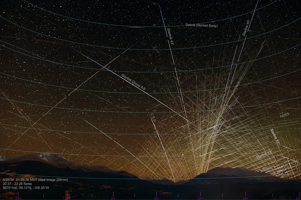
The image above shows both the 43° and 53° inclination shells of the Starlink Satellite Constellation flaring above 14,429′ Mt. Massive, with Mt. Elbert (the highest peak in Colorado) on the left. It was composited from 353 images, 1h 51m of time-lapse captures (from 2037-2226 hrs MDT), with the all satellite flares and transits shown on a base image selected around the center of the time interval. Generally, the flares on the left of the image occurred earlier, while the flares on the right occurred later in the sequence, as the sun moved from west to northwest (left to right).
This was my first trip out in the new 2024 Toyota Land Cruiser, and found me winding my way from Golden over Kebler Pass to Weston Pass, a place I had not been since college! I dropped down the west side toward Twin Lakes and searched out a view to the west, and found myself at an overlook adjacent to San Isabel National Forest, above Box Creek. I had no idea there was such a robust placer mining operation going on in the Box Creek drainage, with various large equipment moving rock all over, throughout the day. I chatted with a couple of bow hunters scoping out the elk down below, and they headed off before sunset to get some sleep prior to their early hike in to search for the elk.
Starlink Satellite Constellation Flaring
This time of year the sun is returning toward the south as we approach winter, and the zone above the sun where low-earth orbit (LEO) satellites flare moves south, as well. Typically, the 53° inclination Starlink orbital shell flares brightly when the sun is 30-40° below the horizon, with the satellites 5-20° above the horizon, directly above the sun. I knew that the highest-latitude transits of the 43° shell would appear very densely concentrated and flaring in the same vicinity, but just a bit south of the 53° flares. I wanted to try and get both in the same image along with Mt. Elbert and some of the vivid yellow aspens, but not having caught this orientation before, it was a bit of a guess as to where it would happen on the horizon.
As it turns out, I caught the geometry of the 43° inclination satellites perfectly, above the sun at the optimal time, and imaged two satellites simultaneously rising from the horizon adjacent to each other. They flared for 3 minutes and 20 seconds, getting brighter as they ascended, then turned blue prior to entering the earth’s shadow at ~45° elevation (the blue color is reflected from the bottom of the spacecraft chassis, which is covered with a blue dielectric mirror coating which reflects less light than a typical satellite, one of SpaceX’s brightness mitigation measures). This was the first time I’ve captured the 43° inclination satellites flaring vertically off the horizon, since the sun needs to be in a very specific geometric orientation, and for a given location (latitude) it likely only occurs so perfectly for a handful of days per year. Throughout much of the year these satellites do flare brightly from the mid-latitudes just after twilight ends, and you can see see them when looking northward, high above the horizon (they do look blue to both the naked eye, and through binoculars).
The following image is an annotated version to highlight some of the notable objects captured in the composite, including:
- 43° inclination Starlink satellites;
- 53° inclination Starlink satellites;
- a Starlink ‘train’ (recent launch of Group 9-8, launched 24 hours prior from Vandenburg AFB, CA);
- Tiangong, the Chinese Space Station (CSS);
- a NOSS satellite pair flaring; and
- several tracks fading in/out, consistent with space debris, most likely discarded rocket bodies.
The following is a timelapse video from the source images; the second half uses a ‘trail’ mode that allows you to see the flares for a longer period, which lets you to visualize the extended tracks (over time) better:
The image below depicts the alignment of the sun (below the horizon) in relation to various satellite flares (the Chinese Space Station is flaring brightly at center, while an unknown satellite flares south of it). The yellow box delineates the 43° satellite flare zone for the time interval (2109-2116 hrs MDT), while the orange box delineates the more compact flare zone of the 53° inclination satellites. Both elevations and azimuths are approximated for each flare zone, and phase angles were calculated for the center of each box. Phase Angle (‘beta’) represents the difference in angle between the declination of the sun (the number of degrees below the horizon), and the elevation of the flare zone above the horizon. These beta angles agree closely with one another, 38° for the 43° inclination shell, and 39° for the 53° shell, however the 43° inclination satellites have a much larger (vertical) range.
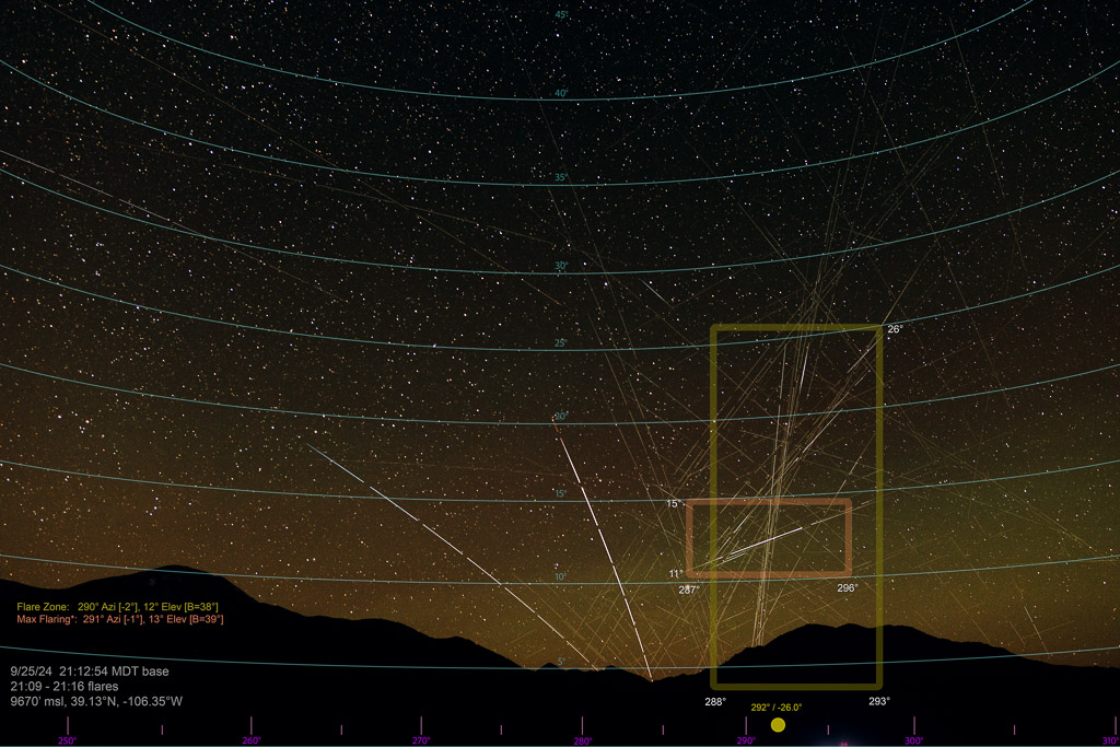
Note how the tracks of the 43° shell flares are both more numerous and quite long in comparison to the 53° flaring. Since these satellites have their nadir side (the ‘bottom’ of the spacecraft, where the antennas that communicate with users on earth are mounted) parallel with the earth’s surface, their reflections are quite consistent, and follow basic geometric principles (e.g. the ‘beta’ calculation). Thus, the width of the flare zones are fairly similar, but the height is vastly different, since a nearly-vertically moving 43° satellite remains oriented above the sun for a longer time interval, until it enters the shadow of the earth and quickly dims. The 53° inclination Starlink satellites typically flare for around 5 to 25 seconds, with the vast majority of them being 15-25 seconds. Since the 43° shell stays directly above the sun longer, they can occasionally flare for multiple minutes. As you can see in the graphic below, the 43° satellites captured in the image are ‘aiming’ nearly directly at the camera location (yellow box), as the camera is capturing the area where multiple planes of the satellites’ highest-latitude transits (the white arcs) are converging at a small vicinity of the sky. This highest-latitude transit convergence of the 53° orbital shell lies outside (right of) the camera’s field of view, and this time of year the sun is too far beneath the horizon to illuminate that zone (this occurs in April and August, at 40° latitude).
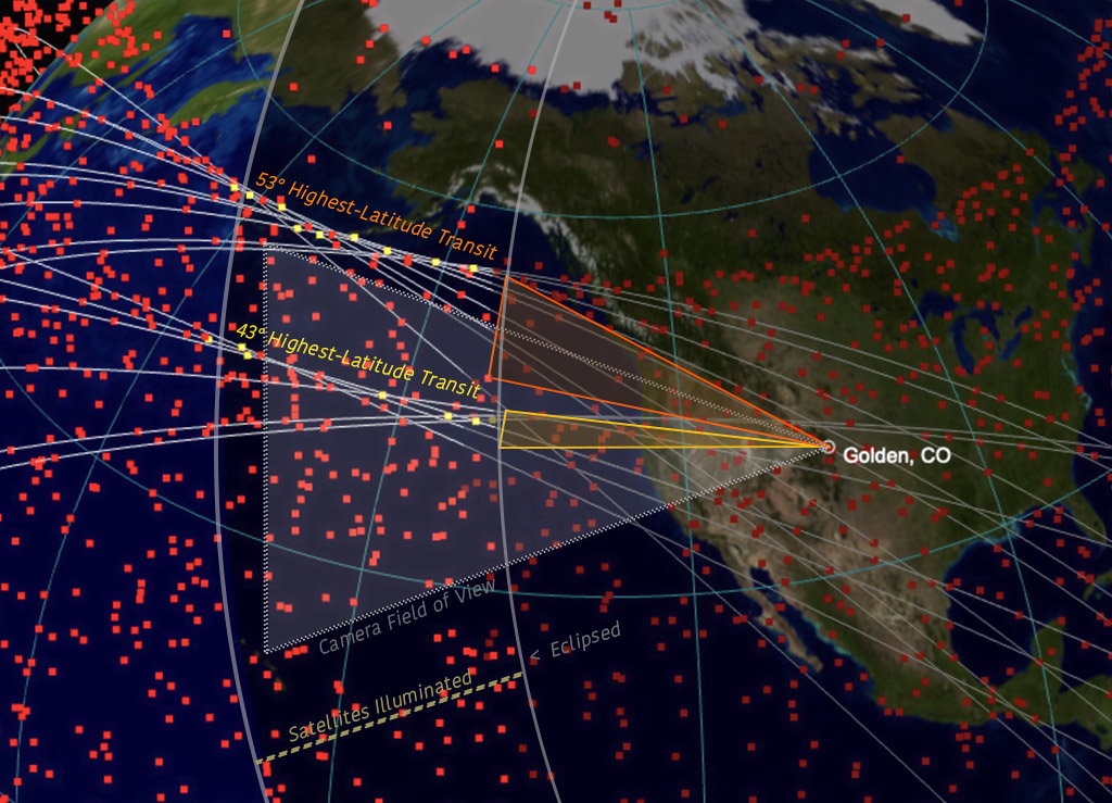
Now, let’s briefly consider both the CSS and the ‘unknown’ flare (furthest south) in the image above. At first I wondered why these two spacecraft manifested such bright flares, considering that they were both quite a ways south of the sun. At least in the case of the CSS, I’d guess that it is because the station’s solar panels follow the sun, thus are optimally oriented to reflect the sun since they are tilted towards it, even though the CSS is not directly above the sun. In the case of most satellites, their nadir side always parallels the surface of the earth, and thus the flaring generally only occurs when the spacecraft lies vertically above the sun, within +/- 5° azimuth. I do not know about the ‘unknown’ flare, but I’d guess that the spacecraft may also have sun-tracking solar panels, and curiously it looks to be located within a 43° inclination.
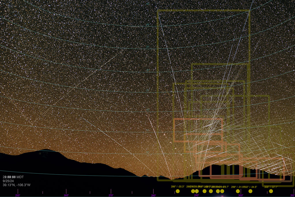
Lastly, below is a composite image that shows all ten time periods for which I calculated flare zones and beta angles. It generally shows the relationship between the movement of the sun from left to right, with the flare zones following and descending, until the sun is ultimately too low to produce flares, which occurred just outside the right edge of the image. Had I aligned the camera to the right another 5 degrees or so, I would have perfectly captured the termination of the flaring. I could try again another ten times during those handfuls of days per year and possibly never get the seasonal timing (latitudinal phase angle) more perfect than this image.
